Sunday, September 30, 2007

MT. SHASTA. This is about the end of our 7 month trip and we are just about to re-enter Oregon. It has been an incredible 'trek' and will have these memories for the rest of my life. Thank you for visiting!

These BLOG pictures are in no progressive order as some are from our 7 month 'Family Reunion' and 'Following the Blues Highway' trip, then I would insert more current 'happenings' pictures, and then go back to my Family Reunion/Blues Highway trip. I am sorry if this is confusing.
From now on the next pictures will be current happenings as I am finished with our 'Family Reunion' and 'Following the Blues Highway' trip.


Yup ~ there was snow in the distance and snow on the side of the freeway... Up and over we go.


We started seeing snow off in the distance but knew we were starting to climb up and over the Siskiyou Summit...


These are "THE CRAGS"
just north of Dunsmuir. To see these in person is so much better.


This is such a gorgeous area of our country!


The beautiful LAKE SHASTA.


Sacramento River and fields of Mustard!


San Joaquin Valley!
We started to see Wine Grape vines


We are getting closer to home with every mile.


As we went further North, we began to see Spring.... and it was really nice to see some color.


Last winter when we were in the AZ desert, there was a very bad frost in California which froze many of the oranges.... We did see many 'workers' in the orange groves, yet lots and lots of oranges on the ground.


Made it to the valley and started seeing those oil drilling machines... We noticed that even though we, as a nation, were crying out for oil... the greater number of these drilling rigs were not moving.... YOU GO FIGURE?

I really enjoyed this view...too bad you can't see where the road goes...but it goes up over the hills in the far distance. In this picture you can see the slope of the descent... Loved our Pac Brake which gave us assurance that we could stop...(and would not wear out the brakes on the way down).


Passed some pretty gorgeous homes with marvelous views.


You can see the beginning of the California smog in the distance.... think we still will have some beautiful scenery ~ just have to look thru the smog.

Now we will descend down to the valley... Here we go!!


Tehachapi Pass is a good road that descends down to the valley and passes through some gorgeous areas.


Heading towards the Mojave Desert and down Tehachapi Pass to the fertile California valley!


Twenty Mule Team (Borax) Road


We are very close to
Edwards Air Force Base!


This is where they make Borax.

Friday, September 28, 2007

Come with us down ROUTE 66!


Route 66!


Route 66!


The wind never calmed down and kept blowing off roofs on homes in Palm Springs. This was the top of the mountain in Palm Springs and you can see the wind and the snow blowing. Even though the sun was out it was chilling cold.


We left Palm Springs and boondocked at Fantasy Springs Casino in Indio as we could not get over the pass to head home because of the wind and snow. The cloudy picture is because of the wind blowing the desert dust.
We stayed at the Casino for 7 days waiting for the weather to change and when it finally changed we left to head home.


If ever in Palm Springs area, check out the Air Museum.


We went to Palm Springs for our Wedding Anniversary dinner at Billy Reed's the same restaurant where we celebrated my 55th birthday a "few years" ago and the meal was still fantastic!
Sometimes restaurants change but this one was still great.


Had to get our Trader Joe's fix and get some "Two Buck Chuck".... you can find the "Two Buck Chuck" in California but in other states it is called "Three Buck Chuck"... We went to Cathedral City to find Trader Joe's!


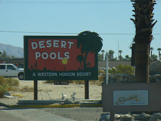
We made it to Desert Pools RV Park for our 3 night 4 day free stay. All we had to do was listen to their sales pitch... So we stayed and rocked and rolled in all the wind.... did not buy!


We left Joshua Tree National Park and headed to Desert Hot Springs in a high wind storm...


We followed that straight, long and narrow road through the desert to Joshua Tree National Park...
Joshua Tree is at elevations from 2,000-5,000 feet.
Follow the blog to Joshua Tree...


Joshua Tree was proclaimed a National Monument on Aug. 10, 1936 by President Franklin D. Roosevelt and redesignated a National Park on Oct. 31, 1994. This is a must see National Park...it is beautiful.


Looking down at our camp site from one of those Jumbo Rocks. This was a wonderful place to camp, walk, hike and explore!
Check out link for more information.


We camped at this campground at Joshua Tree National Park called
'JUMBO ROCKS'.


There are so many places to hike here. Pretty incredible place.


Al found some growing vegetation clinging to some rocks. Out here in this desert one has to wonder how they survive?


Al casting his shadow across the valley...and it worked!!

Al did lots of climbing on the Jumbo rocks and cast his shadow on the rocks across the valley. Pretty cool...